
Boulder Sites: Rocks that Rock
Pelham Bay Park is home to spectacular boulder sites, as well as a rugged, picturesque coastline. Some rock formations are outcroppings, with bedrock emerging from the earth’s surface. Others are isolated glacial erratics that broke off from the bedrock or were transported and deposited here by the flow of glacial ice. Over the years, some of the distinctive boulders in the Park have been given names that commemorate history or evoke legends. Many are thought to have had symbolic associations for the indigenous people who once lived on this land.
To help visitors identify some of the Park’s most prominent boulder sites, pictures and further information are provided below.
Header Photo Credit: Scott Farrington, NYC Parks & Recreation

Twin Island Coast (Photo: NYC Parks & Recreation)
Coastal Formations
The rocky coasts of Twin Island and Hunter Island are made up of a geological formation known as Hartland Schist. This formation is the southernmost outcropping of a bedrock complex that starts on the New England coast of Maine. Striations and furrows seen on these rocks are evidence of the flow of the Wisconsin Glacier, the last of the glacial advances, which reached New York City some 20,000 years ago.

Glover’s Rock (Photo: Deborah Wye)
Glover’s Rock
Located on Orchard Beach Road, not far from its intersection with Park Drive, Glover’s Rock is a glacial erratic and a distinctive natural wonder. The huge boulder is composed of gneiss, a rock type that forms the bedrock underlying the park and most of The Bronx. It is known primarily for commemorating a Revolutionary War battle led by Colonel John Glover. In 1776, Glover and his small band of some 800 soldiers held off the British contingent of 4,000 as they advanced from their landing place at Rodman’s Neck (then known as Pell’s Point). This stand-off gave General George Washington the opportunity to lead his troops across to White Plains.
Grey Mare
A glacial erratic resembling a horse, the Gray Mare sits on marshy land at the northwest point of Hunter Island. It can be seen from across The Lagoon near the Park’s border with Westchester. That land was once home to the estate of Elbert Roosevelt. Historian Bill Twomey writes about Mr. Roosevelt and a local Native American looking across to the Gray Mare, together, sometime in 1808 when the Native American came back to visit the place where he had grown up.

Gray Mare (Photo: Tom Casey)
Indian Rock (Photo: Jorge Santiago)
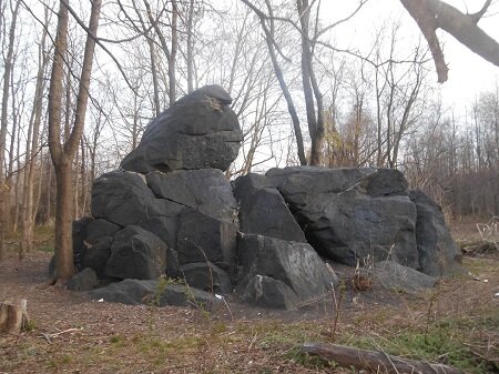
Indian Rock
Among the Park’s most stunning geological sites is a massive boulder site, located in the southern section of the Park in a wooded area just behind the baseball diamond after you pass the dog run. To find the site, walk into the woods from centerfield. However, since such sites were often significant meeting places for the Native Americans who lived in this area, the name Indian Rock has been maintained. This rock formation was long thought to be an outcropping of bedrock. Peter Matt, a geologist from Brooklyn College, studied its surfaces and analyzed them in relation to other rocks around it, and on the shores of Hunter Island and Twin Island. He believes the Indian Rock is a massive erratic boulder broken off the bedrock somewhere north of Pelham Bay Park and swept here by a melting glacier. Local historian and Friends member Jorge Santiago identified this rock formation as the same one that was used to commemorate the Bronx Parks system with a plaque in 1913. That was long before the woods had grown up around it and its prominent placement was obscured.
Mishow Rock
Located at section 3 at the north end of the Orchard Beach promenade, Mishow Rock is right at the start of the Kazimiroff Nature Trail. Only the top of the boulder is now visible. It is thought to be approximately 8 feet tall and 12 feet long, but most of it is buried. During the extension of Orchard Beach, when this area of the shoreline was filled in, naturalist Dr. Theodore Kazimiroff lobbied for the boulder’s importance and helped save it from being completely lost.

Mishow Rock (Photo: Jorge Santiago)

Pelham Bay Naval Camp Boulder, 2014 (Photo: Jorge Santiago)
Pelham Bay Naval Camp, 1917-19, with boulder in background (Photo: Located by Charlie Krieg)
Pelham Bay Naval Camp Boulder
Did you know: a World War I Naval training camp once stood in Pelham Bay Park. Opening on October 1, 1917, it once occupied all of Rodman’s Neck, including the area of the current golf driving range. By March 1918 the base held 4,777 sailors and 537 buildings, most used for barracks. But other structures included the following: drill hall, library, YMCA, Knights of Columbus, Jewish welfare building, Officer’s Club, Post Office, police and fire buildings, photo studio, sixteen mess halls, and also pools, tennis courts, and numerous canteens. Pelham Bay Park, with its vast size and public waterfront, provided an ideal location in which to drill sailors in naval launches as well as sham ground battles and maneuvers. It also allowed for numerous recreational activities like baseball, golf, tennis, band marches, drills, boxing matches, and theater. With the end of the war in November 1918, the sailors began to leave the base. By the end of 1919, the sale of the buildings was completed. Local history buff Charlie Kreig found a photograph showing a group of soldiers at the camp, with a massive outcropping in the background. He and fellow historian Jorge Santiago set out to find it, which they did, just northeast of the City Island Traffic Circle. They were able to match its markings to the boulder in the old image.
Roosevelt Rock
Roosevelt Cove is located on the north end of Shore Road, past the second bridle path crossing. Not far from the inlet is an unusual boulder site with an historic inscription. According to local historian Bill Twomey, the area is known as Haunted Cedar Knoll and once made up the grounds of the Elbert Roosevelt estate. One of Elbert’s sons, Isaac, left a record of his home for future generations in a carving made in 1833 when he was 21 years old. The inscription, “Isaac Roosevelt 1833,” can still be seen etched in the rock nearly 200 years later.

Roosevelt Rock (Photo: Jorge Santiago)

Sphinx Rock (Photo: Jorge Santiago)
Sphinx Rock
Perched on the northeastern edge of Twin Island is the glacial erratic known as Sphinx Rock. A section of the boulder once balanced on top, but broke away and now sits on the ground beside it. An early Parks Department brochure, discovered by local historian Jorge Santiago, indicates that the boulder was also known by the name of Lion Rock.
Split Rock
Located on a small patch of land between the New England Thruway and the Hutchinson River Parkway, at the northwestern corner of the Park, Split Rock provides an awesome site with its massive crevice dividing the boulder in two. A person can easily stand in this break, which most likely was caused by glacial flow thousands of years ago. Legend has it that religious rights activist Anne Hutchinson once lived near this spot in the 1600s and one of her children hid in this crevice during an Indian onslaught. The Hutchinson homestead is now believed to be further to the west. In 1962, when the Thruway extension was built, Split Rock was threatened. Local activists, led by Dr. Theodore Kazimiroff, succeeded in preserving this geological wonder.
Currently, the route is very difficult to access: please visit the Split Rock with the Urban Park Rangers on one of their regular hikes.

Split Rock (Photo: Jorge Santiago)

Tilly’s Rock (Photo: Becky Brown)
Tilly’s Rock
One of the most spectacular spots in the Park is reached by hiking the Kazimiroff Nature Trail on Hunter Island and veering off toward the water on the northeastern coast. We, the Friends of Pelham Bay Park, laid a bog bridge across the salt marsh that allows visitors to cross in a way that does not affect the ecosystem. Taking the trek brings them to an awesome geological area including rocky coast and glacial erratics combined with marshland and tidal pools of the Long Island Sound. According to the late historian John McNamara, Tilly’s Rock – the largest of the boulders seen here – may have been given its name by campers, after someone called Matilda. Or, it may relate to navigation and the tiller used by sailors to change course. They called it “Tiller Rock.” The spelling has sometimes been “Tillie’s,” as cited in a 1936 article turned up by local historian Jorge Santiago.